

Horseytalk.net/Hoofbeat EXCLUSIVE
RIDER RIGHTS

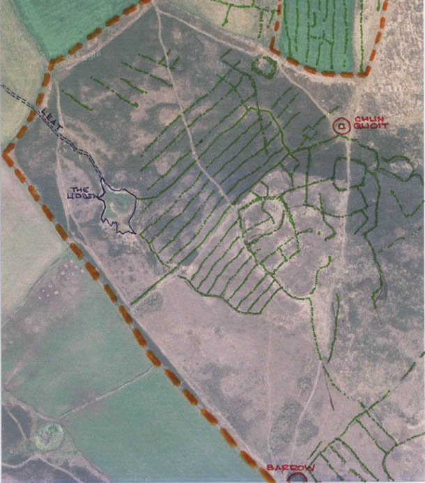
West Penwith, Higher Dows, Chun
 Craig Weatherhill
I thought that I'd let you all see what is now threatened in West Penwith, Cornwall. Higher Downs, Chun, just west of the stone-built Iron Age fort of Chun Castle. The moorland area concerned is Registered Common Land (not all our affected areas are) and, of course, Open Access Land under the CRoW Act. Land within the dotted orange line on the photo marks the boundary of land included as a Scheduled Ancient Monument.
Please bear in mind that this moor has not been grazed within living memory if, indeed, grazing has ever taken place. Generally, darker areas are a mix of dwarf western gorse (grows no more than knee-height), and three types of heather (ling, bell heather and cross-leafed heath). Lighter, yellowish areas are moorgrasses, notably purple moorgrass (or fynny as we call it).
Highlighted in green is one of the finest surviving medieval strip field systems anywhere in Cornwall. These partially overlap a much earlier patter of curvilinear prehistoric fields. Because of their evident association with the Neolithic dolmen of Chun Quoit (3500-2500 BC), which stands at their highest point and provides a focal point, it is thought that these fields might also be of Neolithic origin. If that is so, then they are a remarkable and extremely rare survival of huge archaeological value, particularly as they appear to contain hut platforms.
Despite assurances made to us only a year ago, we now know that this area is targetted for High Level Stewardship "management" by fencing and grazing with cattle.
The prehistoric fields, in particular have only moorgrass cover, and this is precisely what any cattle will be attracted to, as it will be the only half-decent grazing available to them. We know, from Carnyorth Common nearby, that the cattle do not touch the western gorse or heathers. The bank boundaries of these prehistoric fields are low and particularly fragile. They cannot hope to withstand concentrated cloven-hoof activity and will surely be badly damaged or even destroyed.
Nevertheless the local English Heritage representative has (reportedly) stated that she is "very happy" with the grazing proposal. It beggars all belief. This same person stated that grazing would be "of benefit" to the archaeology of Carnyorth Common, where, since then, the Tregeseal stone circle has been damaged eight times in the 2 and a half years since longhorn cattle were introduced.
A few times of infrastructure has already been installed, but there have been no applications under the Commons Act, the Highways Act or the Ancient Monuments and Archaeological Areas Act. Once again, the quangoes are trampling all over the law. This scheme MUST be stopped before it starts, or we lose some of the rarest archaeology in Britain.